Experimental Great Lakes Short-Term Ice Forecast Guidance
DEMO: Nowcast for February 18, 20XX & 5-Day ForecastHow to Read the Forecast Guidance
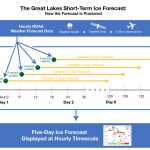
Time Scale
The 5-day forecast guidance provides hourly estimates of future conditions, beginning with a nowcast of present lake conditions based on model simulations using best estimates for meteorological conditions. This product is refreshed four times per day with the latest weather forecast conditions (Midnight, 6 am, 12 pm, 6pm UTC). The model captures lake condition changes every minute. An infographic explaining how the forecast guidance is produced can be found here.
Base Layer & Color Scale
Select either ice concentration or ice thickness as the map’s base layer. Concentration indicates the approximate % coverage of ice over a given area. After selecting the base layer, select either a continuous color scale (Gradient Color Scheme) or a categorical color scale (WMO Color Scheme) developed by the World Meteorological Organization that represents different thresholds of ice thickness. The WMO color schemes are used by the U.S. National Ice Center and the Canadian Ice Service.
Additional Data Layers
After choosing the base layer, select additional data layers including winds, ice velocity, and water temperature. For the winds and ice velocity data layers, the length of the arrows indicate speed in a given region–the longer the arrow, the faster the winds. The length of a grey arrow representing 10kn is depicted for comparison for wind direction. Ice velocity is similarly depicted by the colored arrows–an arrow representing 0.5 kn is pictured for reference.
Water temperature is displayed by contour lines labeled as 0, 2, or 3 degrees Celsius. The darker blue indicates colder temperatures.
Geographic View
Select a preferred geographic view for the forecast guidance by clicking through tabs at the top of the map graphic. In addition to a basin-wide view, specific geographic areas have been offered because they have been identified by users as regions that pose great challenges to winter navigation.
About the Forecast Model
This experimental ice forecast model is a component of the coupled lake hydrodynamic-ice system, the Great Lakes Operational Forecast System (GLOFS) produced by scientists at CIGLR and the NOAA Great Lakes Environmental Research Lab. GLOFS models are currently in transition from research to operations at NOAA NOS/CO-OPS (or potentially U.S. NIC) to provide the first-ever, short-term (i.e., 5 days) ice forecast guidance. More details on the forecast model can be found here.