July 2024 eNewsletter
Differential Impacts of Storm Surge Flooding on Coastal Communities of the Great Lakes
.

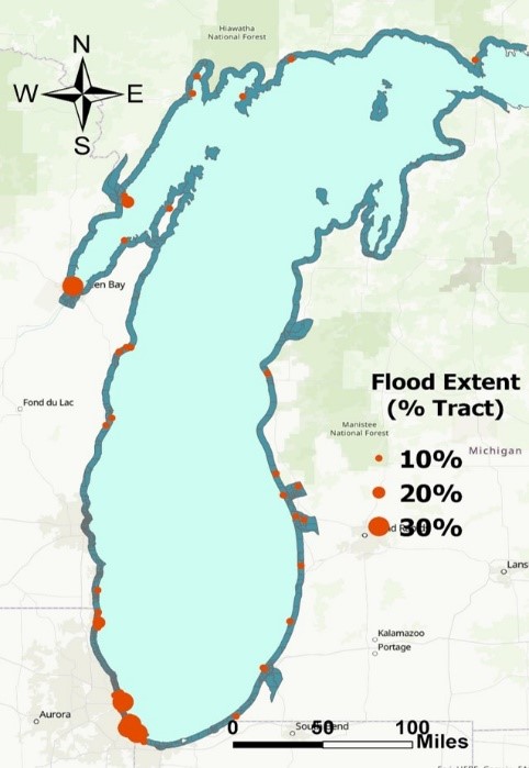
Extreme flood zones (indicated by red dots) on Lake Michigan’s coast have had up to 30% of census tracts flood in the last 3 years. Image by Yi Hong.
Storm surge flooding throughout the Great Lakes region has become more frequent in recent years, causing significant property damage to coastal homes and exacerbating public health issues such as injuries, hypothermia, disease, undernutrition, mental health problems, and more. The adverse impacts of flood exposure are amplified for socially vulnerable populations who disproportionately reside in flood-prone areas. Socially vulnerable populations include, but are not limited to, people without vehicles, people with disabilities, older adults, low income households, and people with limited English proficiency. In order to improve flood resiliency, it is essential to accurately identify both the flood hazard extent for Great Lakes coastal communities and the exposure of different socio-demographic groups to flooding. However, neither of these crucial factors have been comprehensively evaluated in relation to the Great Lakes region.
A research team led by Assistant Research Scientist Yi Hong, PhD (University of Michigan, CIGLR) and collaborators Eric Anderson, PhD (Colorado School of Mines) and Sara Hughes, PhD (RAND Corporation) is using a coastal flood model combined with a social vulnerability analysis to examine the differential impacts of storm-surge flooding on Great Lakes coastal communities. “Climate change and its associated effects such as rising water levels, warming water temperatures, more intense weather events, and coastal flooding disproportionately impact coastal communities, including populations who are already vulnerable due to social or economic factors,” said Hong. “Our team is looking more intentionally and specifically at the negative effects that Great Lakes coastal flooding has on vulnerable communities.”
From 2018 to 2021, the Great Lakes experienced a period of historically high water levels, pushing water farther inland and raising concerns over more extreme storm surge flooding of coastal communities. “Using a recently-developed hydrodynamic lake model, our team is working to simulate coastal flood extent from 2018 to 2021 for all Great Lakes,” said Hong. “But first, we focused on Lake Michigan, because all of the coastal regions are within the United States, and at the time we did not have data (e.g., census tracts, demographic data) for Canadian coastal regions. We looked at the relationship between the proportions of flood-prone areas and key social vulnerability indicators at census tract scale.” (Census tracts are subdivisions of counties for which the United States Census Bureau collects statistical data). “Our results highlighted specific census tracts and populations that need help and intervention to mitigate the impacts of storm surge flooding. For example, Green Bay, Wisconsin, and Chicago, Illinois, are in extreme flood zones on Lake Michigan’s coast. Both areas have had up to 30% of census tracts flood in the last 3 years, causing life-threatening situations for many.”
“As we continue this research, our team is working to embed these results into a real-time flood forecasting system,” said Hong. “This would help reduce disparity and provide advance flood warning to socially vulnerable populations, ultimately enhancing coastal management strategies for the Great Lakes region.”
