Great Lakes Observing & Forecasting Systems
Hydrodynamics and Contaminated Sediments in Manistique River
Overview and Objectives
The Manistique River Area of Concern covers
the last 1.7 miles of the Manistique River. The
The
contamination legacy comes from industrial waste (oils and combined sewer overflows) as well as debris and sawdust from more than a century of logging and milling. Currently, there still remains two beneficial use impairments that include a restriction on dredging and on fish consumption. A multi-agency and multidisciplinary effort is underway in order to understand and remediate the Manistique River. The Cooperative Institute for Limnology and Ecosystems Research (CILER), US-EPA, Great Lakes Environmental Research Laboratory (GLERL), US Geological Survey Water Resources of Michigan, National Marine Fisheries Service and the University of Wisconsin-Madison are working together with the ultimate goal of delisting Manistique River from being an Area of Concern. Extensive field measurements have been conducted by the University of Wisconsin-Madison in order to assess effective remediation actions plans (RAP). In particular, detailed atmospheric, flow, and sediment parameters are employed to further reveal the role of the physical processes on the fate and transport of contaminated sediments. Additionally, the hydrodynamics and sediments data would be used to estimate contaminated sediment residence time, and help identify potential contaminant sources in Manistique River, MI.
The specific objectives of the project are:
- Conduct an extensive fieldwork campaign in the Manistique River to collect observations of water velocities, water levels, temperature, turbidity, discharge, conductivity, and bottom sediment samples for hydrodynamic model calibration. In addition side-scan sonar (SSS) mapping inside the harbor and along Manistique River would be performed.
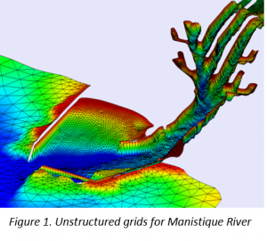
- Sediment material types, critical shear stress, and erosion potential would be obtain for determining bottom sediment characteristics necessary for sediment modeling. Furthermore, field observations would be compiled and prepared for the input of a 3D hydrodynamic model of the Manistique River (Figure 1). Subsequently, the bottom sediment properties and the 3D hydrodynamic model outputs are used as input to a novel sediment particle tracking model.
Publications
Linares, A., Wu, C.H., Anderson E.J., and Anderson, J.D. Role of High-Frequency Water Level Oscillations and Flood Flows on contaminated sediment transport in the Manistique River, Michigan, to be submitted to Journal of Great Lakes Research.
Linares, A., Bechle, A.J., and Wu, C.H. Characterization and Assessment of the meteotsunami hazard in northern Lake Michigan, Journal of Geophysical Research, in review.
Presentations
Linares, A., Bechle, A.J., Wu, C.H., Characterization of High-frequency Water Level Oscillations caused by fast moving storms, AWRA, Wisconsin, Wisconsin Dells, Wisconsin, March 10-11, 2016.
PrincipaI Investigator(s):
Chin H. Wu
(University of Wisconsin)
NOAA Technical Lead(s):
Eric Anderson (NOAA-GLERL)


