Winter 2018 eNewsletter
Featured Research
Predicting Great Lakes Ice
Knowing where and when ice will form on the Great Lakes is valuable information for commerce and human safety. Ice formation affects the operations of the U.S. Coast Guard, commercial shipping and fishing industries, and hydropower generation, as well as the lives of millions of people who take to the lakes for “hard water” recreation. Much of the information needed to predict ice cover is held in history. By understanding how ice cover changes from year to year and identifying long term trends, scientists can more accurately predict the location and timing of ice formation. In the process, they gain insight into weather and climate patterns, lake water levels, and spring plankton blooms.
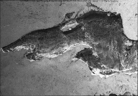
Image of 93% ice coverage on Lake Superior during February 2015. Data Source: National Ice Center; Image Source: Radarsat. *The author would like to acknowledge Macdonald, Dettwiler and Associates, Canadian Space Agency and the NOAA CoastWatch program for the use of this image.*
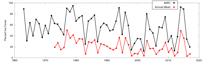
Historical record of annual maximum ice cover and annual average ice cover for all five Great Lakes combined.
CIGLR and NOAA GLERL are working together to develop a regression model that can predict ice cover in the Great Lakes. A regression model determines statistical relationships between two or more variables and allows us to make predictions of one variable based on the others. This particular model determines how ice cover in the Great Lakes responds to lake surface temperature and teleconnections, which are large-scale patterns in the oceans and atmosphere (e.g., El Niño). Because ice cover records go back several decades, there are many years for us to investigate these relationships so that we can make useful projections of maximum ice cover 2-3 months in advance.
The Great Lakes are a complex region for predictions because the weather is impacted simultaneously by several different teleconnections. Currently, the model uses the month-long average of November lake surface temperature and four teleconnections: El Niño Southern Oscillation (ENSO), North Atlantic Oscillation (NAO), Atlantic Multidecadal Oscillation (AMO), and Pacific Decadal Oscillation (PDO).
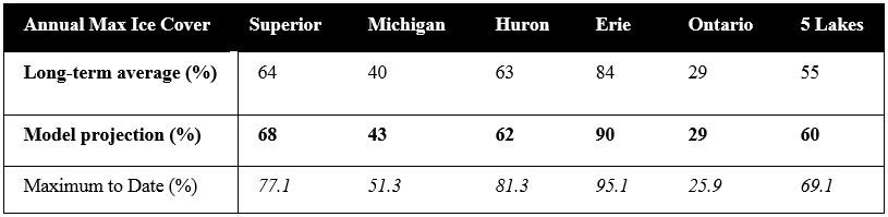
Long-term average of annual maximum ice cover compared to 2018 model projections for each individual lake and for all five Great Lakes combined. The Maximum to Date (taken February 23, 2018) is based on the max ice cover so far in this ice season. Data Sources: National Ice Center and NOAA Great Lakes CoastWatch.
So far in 2018, observed maximum ice cover is within 10% of the predicted values for all the lakes except Huron, which has frozen significantly more than expected. Each spring, the actual maximum ice cover for the year is determined and compared to what the model predicted. By repeating this year after year, we can assess the model’s performance and, if necessary, modify the model to improve the accuracy of future predictions.
The seasonal ice cover forecast is available on NOAA GLERL’s ice forecasting webpage: https://www.glerl.noaa.gov/data/ice/#forecast.
About the Project
The project team is led by Dr. Jia Wang (NOAA GLERL) and includes CIGLR Research Computer Specialists Haoguo Hu and James Kessler. This work was supported by funding from the NOAA Climate Program Office and Great Lakes Environmental Research Laboratory, through the NOAA Cooperative Agreement with the University of Michigan.
Related Resources
- Bai, X., J. Wang, C. Sellinger, A. Clites and R. Assel. 2012. Interannual variability of Great Lakes ice cover and its relationship to NAO and ENSO. Journal of Geophysical Research. 117:C03002. (DOI:10.1029/2010JC006932).
- Wang, J., X. Bai, Z. Yang, A. Clites and H. Hu. 2016. Projection of Great Lakes seasonal ice cover using multi-variable regression models. 23rd IAHR International Symposium on Ice. (Scientific Report)
- Ice Cover on the Great Lakes (Brochure)
- Great Lakes ice images (Flickr album)
- NOAA Great Lakes CoastWatch Statistics (Webpage)
- Great Lakes Ice Cover (Webpage)
- Simulation: Ice cover on the Great Lakes, winter 2014 (Video)