Great Lakes Observing & Forecasting Systems
Implementation of the GLOS-RA Nearshore Observing System Network
Overview and Objectives
The Great Lakes Observing System Regional Association (GLOS-RA) is implementing key observing system and modeling improvements over the 2011-2016 period that focus on critical needs of the Great Lakes region as identified through an extensive needs assessment process. The focus of this work will be on supporting observations and developing new products related to four priority issues affecting the health, well-being, and economic viability of the region, including: climate change impacts; ecosystem and food web dynamics; protection of public health; and navigation safety and efficiency. Critical information needs for these priority areas are addressed by implementation of an array of integrated observations, including new moorings and additional sensors to measure temperature and current profiles. AUV/glider technologies are used to collect critical transect information. Cross-lake ferries and other vessels of opportunity are instrumented to collect repetitive observations of surface chemistry. Satellite remote sensing products are derived to perform daily monitoring of lake surface loadings of nutrients and sediments. Our stakeholder audiences are made up of a variety of public mission agencies that operate in a diverse range of disciplines, in multiple geographic locations, and in various organizations including: U.S. and Canadian Federal government agencies; state, regional, and local government agencies and tribes; NGOs and partner initiatives; academic institutions; and private business, industries and consultants. GLOS targets communications, membership, outreach, and engagement towards those departments, agencies, and individual staff that can contribute to and/or benefit from GLOS programming and that share common goals, objectives, and strategies with GLOS. This includes formal and informal educators, modelers, and researchers who serve as target users in all the GLOS focus areas. CILER’s objective is to oversee the implementation of planned activities for the open-lake observing team that will help to establish, maintain, and develop operational capabilities for the GLOS-RA during project year five of the (Integrated Ocean Observing System) IOOS Cooperative Agreement, covering the time period of June 1, 2015 – May 31, 2016.
I. CILER (PI: Thomas Johengen)
A. Project Management
- Manages and executes the sub-awards for each of the academic institutional participants on the project. The sub-awards are executed through the existing Cooperative Agreement with host lab NOAA-GLERL. Partner institutions include: CILER-University of Michigan, University of Wisconsin-Milwaukee, University of Minnesota-Duluth Large Lakes Laboratory, Great Lake Regional Consortium-SUNY Environmental Sciences and Forestry, Michigan Technological University, and Michigan Technological Research Institute.
- Facilitate and oversee delivery all progress reporting requirements to IOOS.
B. Management of Autonomous Observation Platforms
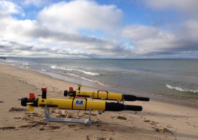
- Support up to 150 days of GLIDER observations in Lake Michigan as part of the 2015 Coordinated Science and Monitoring Initiative (annual bi-national lake-by-lake effort) in conjunction with NOAA, USGS, and EPA. Disseminate the mission data into the IOOS National GLIDER database, as well as disseminate to all of the participating project scientists from the various Federal agencies.
- Complete three AUV (autonomous underwater vehicle/glider) missions in Lake Erie to support ongoing CILER and NOAA efforts to monitor and forecast toxic cyanobacterial algal blooms. Complete a fourth mission planned to support hypoxia monitoring and modeling in Green Bay along with our University of Wisconsin-Milwaukee partner.
C. Operational Support of Lake Michigan GLOS Buoys
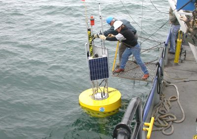
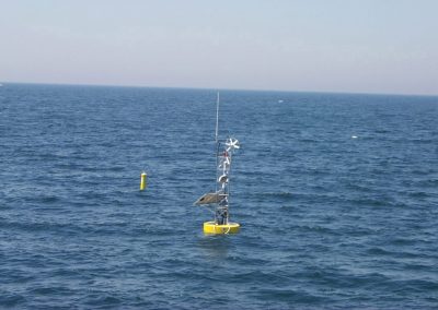
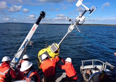
- Deploy, operate, maintain and retrieve a real-time TIDAS 900 buoy with meteorological package, directional wave sensor, currents and thermistor along the coast of Ludington, Michigan.
- Work with MTU to deploy, operate, maintain and retrieve a real-time TIDAS 900 buoy in Little Traverse Bay with meteorological package, directional wave sensor and thermistor string.
- Operate and maintain these buoys during the navigational season of Lake Michigan, reporting all data real-time to GLOS, National Data Buoy Center (NDBC), and the MTRI website.
- Support the operation of a research buoy at the UM Biological station to provide continuous long-term water quality data for support of student research projects and serve as a platform to R&D application of new sensor technologies.
- Provide limited QA/QC and archive all collected data.
- Ensure that both GLOS buoys are reporting data real-time every ten minutes, and transmitting to GLOS, MTRI and NDBC, and that the data is available to the general public via their websites.
II. University of Wisconsin-Milwaukee School of Freshwater Sciences (SFS), Great Lakes WATER Institute (PI: Val Klump & Harvey Bootsma)
A. Real-time Buoy and Vessel of Opportunity Underway Observing Systems, Lake Michigan
- Deploy and maintain two standard GLOS open water monitoring buoys in Lake Michigan off Milwaukee and in Green Bay, Lake Michigan and a third GLWI designed nearshore buoy in the waters of Lake Michigan in the vicinity of the Milwaukee Bight.
- Operate the buoy monitoring systems during the recreational season in the bay (June – October), with the aim of extending this period from May to November. Interface GLOS real time data collection with other ongoing monitoring and research efforts in the Milwaukee region.
- Collaborate with the National Park Service Lake Michigan monitoring program, an objective of which is the identification of conditions that lead to avian botulism outbreaks.
- Continue to assist in the development of long term forecast systems and models for the prediction of future conditions.
- Operate and maintain the high speed ferry vessel of opportunity monitoring program (Lake Express).
- Collaborate with NOAA NCAR in assessing ozone distribution patterns over Lake Michigan.
- Support AUV (autonomous underwater vehicle/glider) missions deployed by GLOS for mapping water quality conditions, depending upon availability and scheduling, and with an emphasis on mapping nearshore habitat, river plume impacts, and seasonal hypoxia.
- Support research projects funded from other sources, e.g., impact of invasive dreissenids on Lake Michigan carbon and phosphorus dynamics, supported by Wisconsin Sea Grant and GLRRIN; research on seasonal hypoxia, watershed impacts and climate change in Green Bay supported by NOAA CSCOR CHRP, the Michigan Water Center, and the Wisconsin Sea Grant program.
III. University of Minnesota, Duluth (PI: Jay Austin)
A. Real-time Meteorological Buoy Glider Deployments and Harbor Instrumentation.
- Deploy two meteorological buoys in the western arm of Lake Superior with NDBC designations 45027 and 45028. Measurements include wind speed and direction, air temperature, relative humidity, water temperature at ten depths, solar radiation, downward longwave radiation, precipitation, and wave height, period, and direction. Data are downloaded periodically to a lab at UMD for QA/QC and archiving. Data are ported directly to NDBC and GLOS every 10 minutes.
- Deploy the glider for 4 separate transects (one each in June, July, August, and September) between the Keweenaw Peninsula and Isle Royale in collaboration with Michigan Technological University (MTU). This transect takes six days to complete. The glider measures temperature, conductivity, chl-a fluorescence, CDOM fluorescence, backscatter, and dissolved oxygen.
- Deploy automated water quality sensors at (a) the Superior Inlet (SI) of the St. Louis River (SLR) to L. Superior; (b) on a mid SLR channel range cell near the Blatnik Bridge, in the connecting channel between the Duluth Harbor/Duluth Bay and the lower reaches of the St Louis Estuary; and (c) at the Duluth Inlet (DI) to Lake Superior. Measurements include flow, temperature, DO, EC25, turbidity and chlorophyll fluorescence.
IV. Great Lakes Research Consortium, State University of New York College of Environmental Science and Forestry (PI: Gregory L. Boyer)
A. Real Time Meteorological Buoy Deployment
- Deploy a TIDAS 9000 series buoy off Oswego, NY with a full meteorological suite, a thermistor string running surface to bottom at 2 m intervals. YSI or HydroLab multi-parameter sonde with T, µ, DO, and pH.
- Use the current GLRC website to provide easy access to basic water quality information, the temperature profile, and meteorological information, as well as support transfer of that information to GLOS DMAT.
- Validate this information through biweekly or monthly grab samples collected at the buoy location in conjunction with SUNY- Oswego. Comparison of buoy data with ship-based measurements conducted through the US-EPA and Environment Canada bi-national sampling program in Lake Ontario as well as with riverine measurements collected by USGS and the Upstate Freshwater Institute.
- Develop and outreach and education program in consultation with the H. Lee White Maritime Museum in the City of Oswego. Included in this will be to co-supporting at least one internship from SUNY-Oswego in science education and outreach.
- Deploy a TIDAS 900 series buoy in eastern Lake Ontario and transfer the data to the H. Lee White Maritime museum and to the GLOS DMAC system.
V. Michigan Technological University (PI: Guy Meadows and Robert Shuchman)
A. Nearshore Buoys, Keweenaw Waterway Observatory, and Glider Support Activities
- Deploy and operate the three GLOS buoys: two off the north and south entrances to the Keweenaw Waterway of Lake Superior and one in Little Traverse Bay of Lake Michigan from late May to late October 2015. A microcontroller-based power management system has been designed, built, and tested and will be added to the north Keweenaw buoy on an experimental basis for this deployment year. All buoys will transmit data every ten minutes and be available near-real time via the GLOS, NDBC, and UGLOS web sites. Develop and test novel power generation methods designed to harvest energy from wave action.
- Deploy two separate thermistor chains at the north and south entries of the Keweenaw Waterway. The temperature sensors will be located at six, one meter intervals (surface to bottom) and will remain deployed from late May to October. After QA/QC, 2010-2015 data will be provided to the GLOS information system.
- Continue to host the interactive web site (uglos.mtu.edu) that reports the real-time observations.
- Continue to maintain equipment and archive video stills, and Met data for three GLRC rooftop HD web cameras.
- Continue to work with UMN-D Large Lakes Observatory (LLO) to deploy, recover, and support additional GLOS trans-lake glider missions. Up to four round trip missions to Isle Royale will be conducted in the 2015 season.
B. GLOS Remote Sensing Activities
- In support of remote sensing product continuity for the Great Lakes, MTRI will continue using the MODIS and its follow-on sensor VIIRS to generate weekly CPA-A products. MODIS is operating beyond its expected operational lifetime. Both satellite products will be delivered to the GLOS Data Management and Communications (DMAC team.
- Generate satellite retrieval products (chlorophyll (chl), dissolved organic carbon (doc), colored dissolved organic matter (cdom), suspended minerals (sm), light extinction coefficients (kd, KPAR), photic depth, and lake surface temperatures (LST)) for the times and areas that the University of Minnesota-Duluth glider operated in 2014. The surface satellite observations will be compared with Dr. Austin’s glider measurements. A co-authored note on the joint analysis will result.
- Using data assimilation techniques developed by Drs. Dave Schwab and Eric Anderson, satellite-derived products of chl will be combined with particle tracking models to show the utility of combining satellite maps on non-cloudy days with a hydrodynamic model to capture a more robust understanding of the Great Lake processes.
- Continue to update the Great Lakes Optical Properties Geospatial Database (GLOPGD) as more data sets are collected this summer field season.
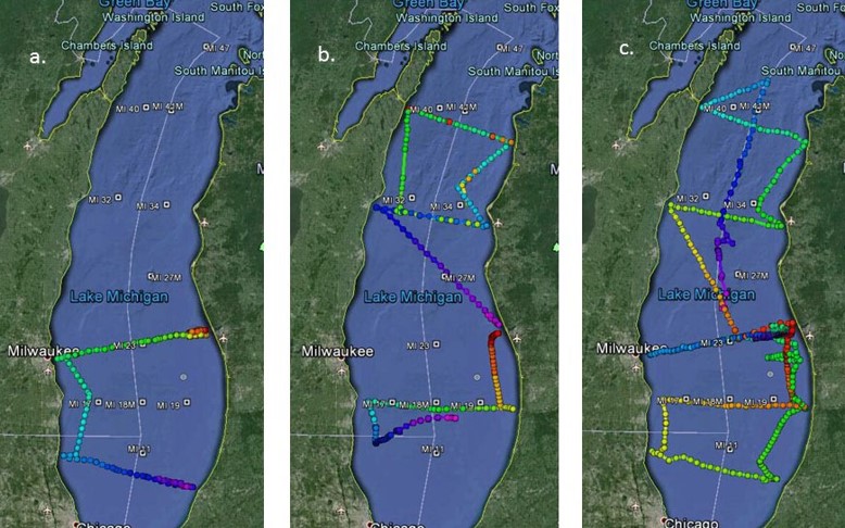
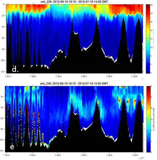 Figure a. shows 6-19 to 7-15 2015 glider deployment track, figure b. 7-14 to 8-18-15 deployment track, figure c. shows 9-21 to 11-10-15 deployment track for UM glider alongside the EPA/UMD glider. Figure d. is the temperature profile for the 6-19 deployment while figure e. shows the chlorophyll profile for the same deployment.
Publications
Fiorentino, L. and J. Austin, Spatial and temporal structure of the benthic nephloid layer in Lake Superior. International Association of Great Lakes Research annual meeting, Burlington, VT. May 2015.
Bernstein, D.N, Austin, J.A, Xue, P, Spence, C., and Blanken, P.D., Estimation of the Spatial Distribution of Evaporative Flux on Lake Superior. IAGLR 2015.
Kerfoot, W.C., S.C. Savage. 2016. Multiple inducers in aquatic foodwebs: Counter-measures and vulnerability to exotics. Limnol. Oceanogr. 61:382-406.
Kerfoot, W.C., N. R. Urban, C.P. McDonald, R. Rossmann, H. Zhang. 2016. Legacy mercury releases during copper mining near Lake Superior. J. Great Lakes Res. 42:50-61.
Kerfoot, W.C., M.M. Hobmeier, F. Yousef, B M. Lafrancois, R.P. Maki, J.K. Hirsch. 2016. A plague of waterfleas (Bythotrephes): impacts on microcrustacean production in a large inland-lake complex. Biol. Invasions 18: 1121-1145.
Fahnenstiel, M.J. Sayers, R.A. Shuchman, F. Yousef, S.A. Pothoven. 2016. Lake-wide phytoplankton production and abundance in the Upper Great Lakes: 2010-2013. J. Great Lakes Res. 42(3):619-629.
Presentations
Grimm, A., C. Brooks, M. Sayers, R. Shuchman, M. Auer. 2015. Mapping Submerged Aquatic Vegetation in the Great Lakes Using Satellite Imagery, 9th Biennial State of Lake Michigan/15th Annual Great Lakes Beach Association Joint Conference (Presentation), Acme, MI. 23-30 October, 2015
Miller,R., T. H. Johengen , H.A. Vanderploeg, J. Hoffman, T. Hollenhorst, L. Fiorentino, J. Austin. Application of GLIDERs to map nearshore-offshore gradients in thermal structure, coastal inputs and biological distributions during 2015 Lake Michigan CSMI, IAGLR, Guelph, Ontario, CA. 6-10 June, 2016.
R. A. Shuchman, G. L. Fahnenstiel , M. Sayers, G. Leshkevich. 2015. Development of New Regional Carbon Monitoring Products for the Great Lakes Using Satellite Remote Sensing Data (Poster). International Ocean Colour Science (IOCS) Meeting, San Francisco, CA. 15-18 June, 2015.
Kerfoot, W.C., M.M. Hobmeier, F. Yousef, BM Lafrancois, R.P. Maki, J.K. Hirsch. A plague of waterfleas (Bythotrephes): Impacts on community structure and secondary production. 2016 ASLO meeting Santa Fe, NM.
Products
PrincipaI Investigator(s):
Tom Johengen (CILER)
NOAA Technical Lead(s):
Steve Ruberg (NOAA-GLERL)
Testing Autonomous Underwater Vehicles (AUVs) in Lake Michigan near Muskegon for mussel mapping. The vehicles were deployed along the Muskegon long-term research transect and they safely returned. September 30, 2014. Credit: NOAA
GLERL portable observatory buoy. Datalink buoy deployment, October 3, 2002. Lake Michigan. S. Ruberg and D. Donahue. http://www.glerl.noaa.gov/obs
Buoy in western Lake Erie for harmful algal bloom monitoring and research, July 29, 2015. Credit: NOAA

