Summer 2023 eNewsletter
Simulating Historic Flood Events in the Duluth-Superior Harbor

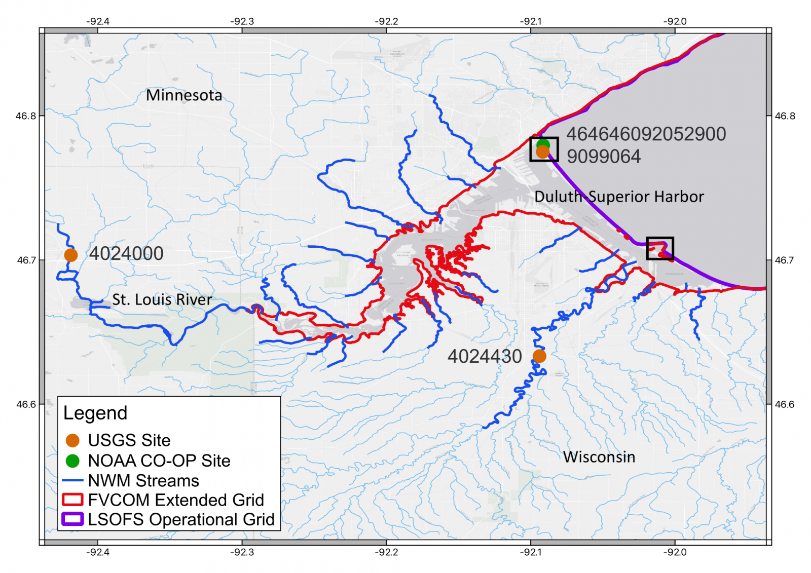
St. Louis estuary (STLE), including the St. Louis River and Duluth-Superior harbor. The purple outline shows the extent of the operational grid from the Lake Superior Operational Forecast System. The red outline shows the extent of the extended high-resolution grid that covers the upstream portion of the STLE and floodplain.
Despite its status as the largest and most heavily-trafficked port in the Great Lakes, the Duluth-Superior harbor is not currently supported with navigational guidance to ensure safe transport. Its location in the St. Louis Estuary (STLE) on the far western edge of Lake Superior makes the harbor highly susceptible to flooding and adds complexities to navigation, raising the priority for developing navigational support for this area. A team of scientists from CIGLR, NOAA’s Great Lakes Environmental Research Laboratory (NOAA GLERL), and NOAA’s National Ocean Service (NOS) are collaborating on research to fill this need by linking existing lake and river models.
On the lake side, NOAA’s Great Lakes Operational Forecast System (GLOFS) is a hydrodynamic model that provides guidance on lake water levels, water temperatures, currents, and ice, but that coverage does not extend all the way into the harbor. On the river side, the National Water Model (NWM) is a hydrologic model that provides streamflow data across the continental United States, including the St. Louis River, but stops just short of the harbor. The result is a “blind spot” within the STLE where guidance is not available for water levels, flooding potential, or currents. “Due to the unique geography, the region is extremely susceptible to flooding events from heavy rain and/or storm surge,” said CIGLR Research Scientist Dmitry Beletsky, PhD. In June 2012, a low-pressure system dropped 5-10 inches of heavy rain over a two-day period, creating over $100 million in damage and causing extreme upstream flooding. In October 2019, the region again experienced heavy flooding, this time driven by a rapid drop in air pressure, strong winds, and storm surge from the lake into the harbor.
To fill the coastal flood forecasting gap for this area, the NOAA-CIGLR research team created a high-resolution model extension into the harbor and across the flood plains. They accomplished this by inserting streamflow from the NWM into the hydrodynamic lake model using a linked framework. “Next, our team worked on simulating past extreme flood events and evaluating the model output,” said CIGLR Hydrological Modeler Lindsay Fitzpatrick. “Simulations were created for the 2012 heavy rainfall event and the 2019 storm surge event. Model results for both events compared well against the time-series of water level and streamflow at observational gauges, but the inclusion of NWM-simulated streams improved accuracy.”
A flood extent survey, which evaluates flood risk and how that risk can be managed, was conducted in response to the 2012 event. Modeled flood extent and depths matched well with the observational inundation maps from the survey. The addition of the NWM tributary streamflow improved the accuracy of modeled water levels and increased simulated surface current speeds by up to 0.5 ms^-1 inside the harbor. “The ability to accurately simulate and predict current changes within the harbor is an important step toward improving the safety of commercial shipping vessels and other watercraft, as well as our response time to environmental disasters such as oil spills,” said Fitzpatrick.
“This study demonstrates that hydrodynamic models in the Great Lakes can be extended to produce accurate simulations of dynamics within coastal features, and is a step toward filling this critical gap,” said Beletsky. “Future work includes extending research and development to other coastal infrastructures within the Great Lakes, such as the Keweenaw Waterway in Michigan, which is currently unresolved in GLOFS.”
About the Authors: Dmitry Beletsky’s, PhD, research expertise lies in the hydrodynamics of lakes and coupling lake physics with biological processes. He has worked on hydrodynamics and climatology of several large lakes in Europe (Ladoga and Onega), North America (Great Lakes and Lake Champlain), and the Baltic Sea. His major scientific interest is climatology and long-term changes of circulation patterns in the Great Lakes.
Lindsay Fitzpatrick is a hydrological modeler, working on a series of projects related to the development, testing, and deployment of hydrological models across the Great Lakes basin. She is highly experienced running WRF-Hydro and, in addition to creating a one-way coupled framework using NWM and hydrodynamic models, she is working to assess NWM-simulated runoff and helping to develop the next generation of Runoff Risk tools.
Related Articles and Resources:
-
- Fitzpatrick, L., Titze, D., Anderson, E.J., Beletsky, D., Kelley, J.G.W. (2023). Simulating flood events at the Twin Ports of Duluth-Superior using a linked hydrologic-hydrodynamic framework. Ocean Dynamics. 73:433-447. (DOI:1007/s10236-023-01559-7).
