Lake-effect snow is one of the Great Lakes region’s most dramatic winter events. Anyone who has lived downwind of the lakes knows how quickly a calm morning can turn into whiteout conditions as narrow snow bands intensify overhead.
These bands form when cold air sweeps over the warmer lake, picking up moisture that rises, cools, and turns into snow. If the wind aligns just right, this rising air funnels into narrow bands that can drop heavy snow over tiny areas. Locals know the drill: these storms can hit fast and hard, yet they remain a challenge for even the best weather models to predict.
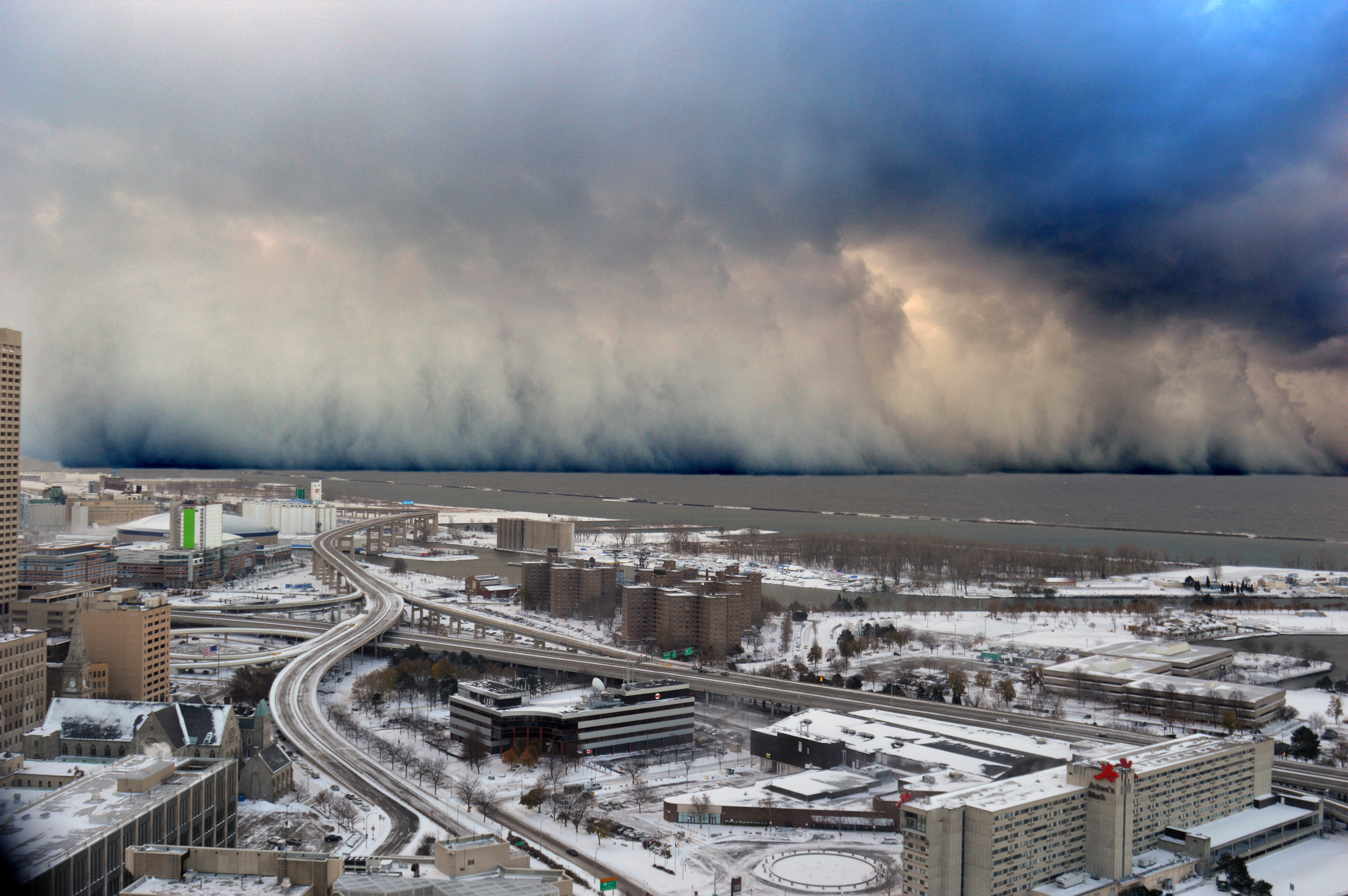
A wall of intense snowfall descending on the Buffalo, NY, Southtowns during the first of two historic back-to-back lake-effect snow events in November 2014. Image ID: con00080, NOAA’s National Weather Service (NWS) Collection; Location: New York, from top of Buffalo City Hall; Photo Date: 2014 November 14; Photographer: Shawn Smith; Credit: NOAA Weather in Focus Photo Contest 2015
A new study led by CIGLR Assistant Research Scientist Abby Hutson, in collaboration with NOAA, the University of Michigan, and the University of Illinois Urbana-Champaign, sheds light on one major reason why forecast models often struggle to capture how snowflakes grow and behave in these intense lake-effect bands.
The Microphysics Behind Snowflake Formation –
At the heart of snowfall prediction is a simple but important idea: snowflakes are not all the same, and their differences matter. Fluffy, branching flakes fall differently and pile up differently than small, dense crystals. Forecast models try to account for this using “microphysics” schemes, which estimate snowflake size and number inside a storm. But these schemes were mostly developed for large, deep winter systems, not the shallow but powerful convection that drives lake-effect snow. As a result, they often miss the full range of snowflake sizes found in these events.
“Lake-effect snow occupies a completely different regime than the snow that falls out of large-scale systems,” said Hutson. “The distribution of snowflake sizes is fundamentally different. Forecasting lake-effect snow accumulation is difficult for models, because they were trained on data that were gathered in an environment not-at-all like those we see in the Great Lakes Region.”
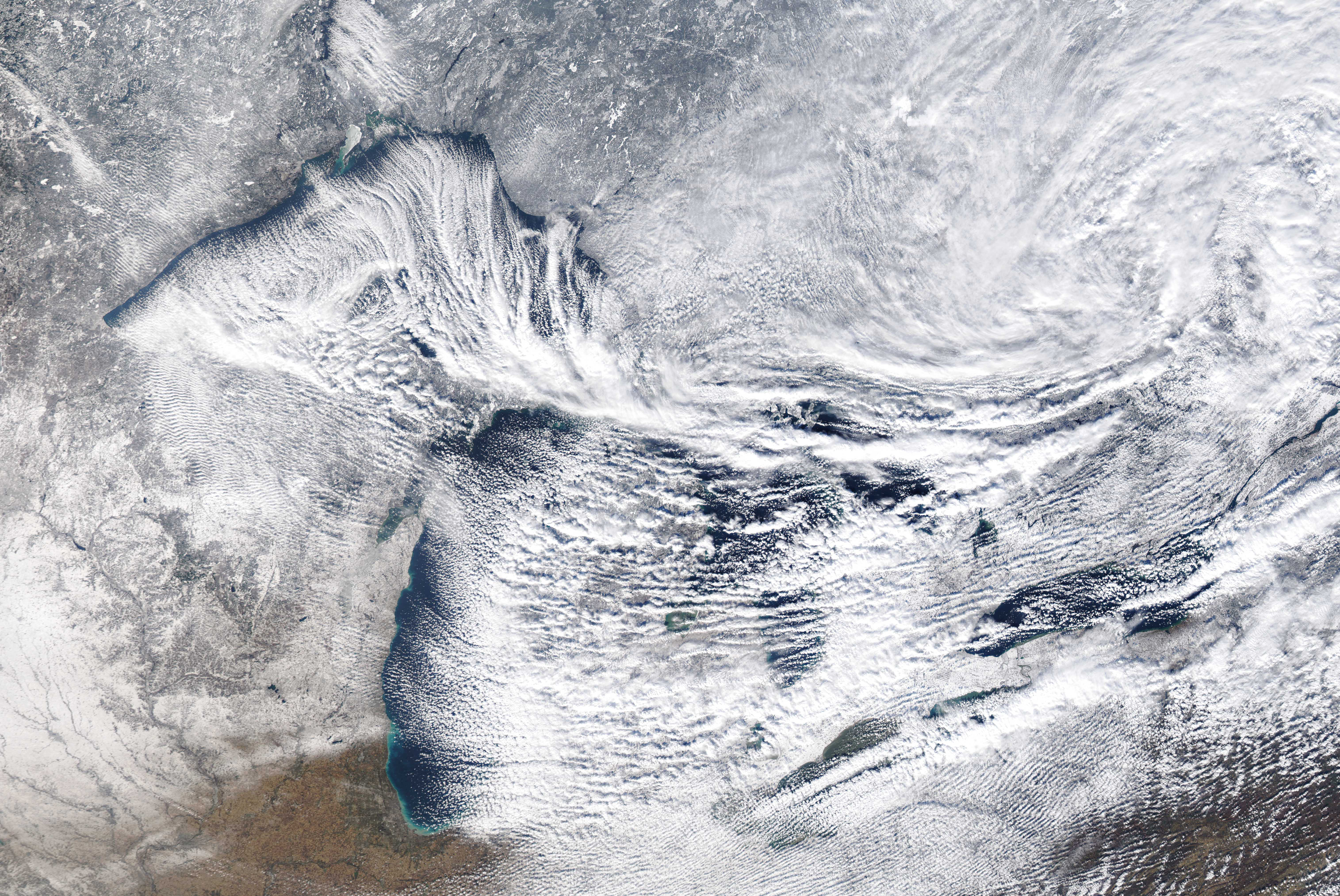
To investigate this, Hutson and her team tested two widely used microphysics schemes, the Thompson-Eidhammer model and the Morrison model, using detailed observations from three major lake-effect snowstorms. These storms impacted Marquette, Michigan; Gaylord, Michigan; and Buffalo, New York, locations known for frequent and intense lake-effect snow. The team compared model estimates with real measurements from storms in November 2022, December 2022, and January 2022.
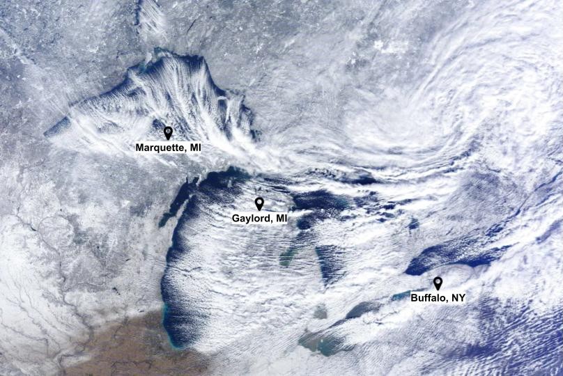
Satellite view of lake-effect snow bands impacting Marquette, Michigan, Gaylord, Michigan, and Buffalo, New York, three sites used in this study to evaluate how forecast models handle snowflake formation.
“The Thompson-Eidhammer scheme is currently used in our operational short-term forecast models here in the U.S.,” said Hutson. “The way it predicts snow particle sizes is through a complicated regression, but it ultimately only predicts one aspect of the way the distribution looks (think height or width of a distribution). The Morrison scheme, which is well-established but not currently used in any operational models, predicts multiple aspects of the snow particle size distribution. We wanted to see whether this approach, using more environmental factors, could better estimate lake-effect snowflake sizes.”
This study is the first to use such a large and detailed dataset of lake-effect snowflake sizes to evaluate operational forecast models. The results highlight just how complex these storms are, and how differently models perform depending on location.
What the Models Revealed –
Model performance varied noticeably across sites. For example, the Thompson-Eidhammer scheme struggled in Marquette, MI, where rising pockets of warm air often create a wide range of larger flakes. Across most sites, both models underestimated the number of very large flakes, those over 6 millimeters wide. Buffalo, NY, was an exception: both the models and observations showed snowflakes larger than 10 millimeters, a hallmark of the region’s famously intense lake-effect snow bands.
“I was surprised to see how differently the Thompson-Eidhammer scheme performed from site to site,” said Hutson. “It captured the extreme snowflake growth in Buffalo, NY, remarkably well, likely because those bands can be so intense. But in the colder northern sites, especially Marquette, MI, it struggled to represent the large, fluffy flakes that are so common in lake-effect events. The Morrison scheme also had difficulty, often missing the large numbers of smaller flakes that fall in these storms.”
Snowflake size plays a key role in determining where snow accumulates. Large flakes fall quickly, piling up near the lakeshore, while smaller flakes drift farther inland. When models underestimate big flakes, they tend to shift the heaviest snowfall inland, away from where it actually occurs. This helps explain why some lake-effect forecasts place the snowfall maximum too far from the lakes, even when real-time observations show otherwise.
“Forecasting the correct distribution of snowflake sizes is important not only because it affects where the snow falls relative to the lakes, but also because it has implications for the hydrology of the Great Lakes Region,” said Hutson. “Big, fluffy snowflakes accumulate and pack differently on the ground, which ultimately impacts how the snow melts with time.”
Improving Lake-Effect Forecasts –
“Even with these modeling challenges, there’s a bright side,” Hutson said. “Both microphysics schemes usually get the overall shape and path of the snow bands right, even if they miss the fine details inside. That means improving forecasts may not require overhauling the whole system, just updating how the models handle snowflake formation and growth in lake-effect conditions. But the only way we can do this is by continuing to observe these events, both of the snow that falls and the lake-atmosphere energy exchange that causes it.”
Lake-effect snow doesn’t behave like other winter storms. These events feature rising pockets of warm air, rapidly growing snowflakes, gusty turbulence, and even flakes that evaporate as they fall. The complexity of these processes means weather models need special adjustments to accurately capture how lake-effect storms form and behave.
The Importance of Observations –
High-quality observations are essential for this work. The longest-running dataset in this study comes from the National Weather Service (NWS) station in Marquette, MI, led by Professor Claire Pettersen (University of Michigan) and Dr. Mark Kulie (NOAA). Supported by NOAA, NASA, and dedicated NWS staff, this site provides one of the world’s few long-term records of snowflakes sizes. These observations give scientists an exceptional view into storm structure and help ensure forecast improvements are grounded in real-world evidence, not just assumptions.
“Without these long-term observations of snow microphysics, we would have no idea that lake-effect snow occupies a completely different regime than snow from large-scale winter storms,” Hutson said. “To improve our models, we need to make sure we truly understand our weather systems – especially with the unique lake-atmosphere interactions that are endemic to the Great Lakes Region.”
Lake-effect snow is notoriously unpredictable, but studies like this are helping forecasters better understand these complex winter storms.
“At CIGLR, we want to help our local communities in every way possible. For me, that means researching the performance of weather models that local NWS meteorologists use to make forecasts. The NOAA-funded researchers who develop our operational models are always wanting to learn how model performance can be improved, and I hope our work in the Great Lakes region means greater understanding for everyone.”
– Abby Hutson, PhD
With improved microphysics and continued observations, communities around the Great Lakes can look forward to more accurate and reliable snowfall predictions when it matters most.